10th May, 2016 12:00
Maritime and Scientific Models, Instruments & Art ('Courageous')
66
[M] "FLAGGEN ALLER SEEFAHRENDEN POTENZEN UND...
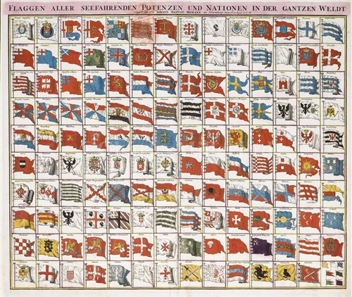
"FLAGGEN ALLER SEEFAHRENDEN POTENZEN UND NATIONEN IN DER GANTZEN WELDT" ["FLAGS OF ALL THE SEAFARING POWERS AND NATIONS OF THE WORLD"], NURENBERG, CIRCA 1710-15(?)
a rare and visually impressive chart, on laid paper, "Presented by" Johann Baptist Homan, Nurenberg, circa 1710-15, featuring 140 engraved flags with contemporary hand-colouring, slight marginal fraying but no significant loss, backed and mounted for display, -- 26 x 22in (67 x 57cm)
Johann Baptist Homan (1664-1724) was one of the greatest German geographers and cartographers and the founder of a publishing house (in 1702) which rapidly became so successful that it was widely credited with the international revival of German printing after almost two centuries of Dutch domination. Appointed Imperial Geographer to the Austrian Emperor Charles VI in 1715, largely as a result of the publication of his magnificent folio atlas in 1710, it has been suggested that this excessively rare flag chart may have been produced as an accompaniment to that atlas. By the time he died in 1724, Homan had issued over 200 maps of superb quality and guaranteed the reputation of his publishing house, which thrived under the name of Homann Heirs for the next hundred years.
Sold for £1,054
Estimated at £400 - £600
(inc. buyer's premium of 24%)
"FLAGGEN ALLER SEEFAHRENDEN POTENZEN UND NATIONEN IN DER GANTZEN WELDT" ["FLAGS OF ALL THE SEAFARING POWERS AND NATIONS OF THE WORLD"], NURENBERG, CIRCA 1710-15(?)
a rare and visually impressive chart, on laid paper, "Presented by" Johann Baptist Homan, Nurenberg, circa 1710-15, featuring 140 engraved flags with contemporary hand-colouring, slight marginal fraying but no significant loss, backed and mounted for display, -- 26 x 22in (67 x 57cm)
Johann Baptist Homan (1664-1724) was one of the greatest German geographers and cartographers and the founder of a publishing house (in 1702) which rapidly became so successful that it was widely credited with the international revival of German printing after almost two centuries of Dutch domination. Appointed Imperial Geographer to the Austrian Emperor Charles VI in 1715, largely as a result of the publication of his magnificent folio atlas in 1710, it has been suggested that this excessively rare flag chart may have been produced as an accompaniment to that atlas. By the time he died in 1724, Homan had issued over 200 maps of superb quality and guaranteed the reputation of his publishing house, which thrived under the name of Homann Heirs for the next hundred years.
a rare and visually impressive chart, on laid paper, "Presented by" Johann Baptist Homan, Nurenberg, circa 1710-15, featuring 140 engraved flags with contemporary hand-colouring, slight marginal fraying but no significant loss, backed and mounted for display, -- 26 x 22in (67 x 57cm)
Johann Baptist Homan (1664-1724) was one of the greatest German geographers and cartographers and the founder of a publishing house (in 1702) which rapidly became so successful that it was widely credited with the international revival of German printing after almost two centuries of Dutch domination. Appointed Imperial Geographer to the Austrian Emperor Charles VI in 1715, largely as a result of the publication of his magnificent folio atlas in 1710, it has been suggested that this excessively rare flag chart may have been produced as an accompaniment to that atlas. By the time he died in 1724, Homan had issued over 200 maps of superb quality and guaranteed the reputation of his publishing house, which thrived under the name of Homann Heirs for the next hundred years.
Auction: Maritime and Scientific Models, Instruments & Art ('Courageous'), 10th May, 2016
