30th Oct, 2013 12:00
Maritime and Scientific Models, Instruments & Art (Powerful)


118
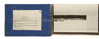
[M] A SET OF D-DAY LANDING INTELLIGENCE BLACK AND...
comprising twenty-one conjoined 8 x 11in. plates, each in turn representing three to four annotated images showing landmarks, contained within cloth-bound covers and typewritten label inscribed FRANCE NORTH COAST Admiralty Charts: 2613,F.1016.G.S.G.S.4250 Sheet 7F/2. Coastal silhouette from VAUX (945863) to 803675 taken at zero feet and at right angles to the coast: distance off-shore about 1,000 to 1,500 yards... and dated March 1944 to accompany Chartlet F.1016A. -- approximately 6 metres in total
Sold for £3,224
Estimated at £200 - £400
(inc. buyer's premium of 24%)
Condition Report
Cloth covers a little spotted with mildew, photo edges generally good but bear guillotine marks along top edge, joints appear strong but are a little rubbed.
We are pleased to provide you with a general report of the condition of this property. Since we are not professional conservators or restorers, we urge you to consult with a restorer or conservator of your choice who will be better able to provide a detailed, professional report. Prospective buyers should inspect each lot to satisfy themselves as to condition and must understand that any statement made by Charles Miller Ltd is merely a subjective, qualified opinion. Prospective buyers should also refer to any Important Notices regarding this sale, which are printed in the Sale Catalogue. NOTWITHSTANDING THIS REPORT OR ANY DISCUSSIONS CONCERNING A LOT, ALL LOTS ARE OFFERED AND SOLD “AS IS” IN ACCORDANCE WITH THE CONDITIONS OF BUSINESS PRINTED IN THE SALE CATALOGUE.
comprising twenty-one conjoined 8 x 11in. plates, each in turn representing three to four annotated images showing landmarks, contained within cloth-bound covers and typewritten label inscribed FRANCE NORTH COAST Admiralty Charts: 2613,F.1016.G.S.G.S.4250 Sheet 7F/2. Coastal silhouette from VAUX (945863) to 803675 taken at zero feet and at right angles to the coast: distance off-shore about 1,000 to 1,500 yards... and dated March 1944 to accompany Chartlet F.1016A. -- approximately 6 metres in total
Auction: Maritime and Scientific Models, Instruments & Art (Powerful), 30th Oct, 2013

